Remote sensing applied for the estimation of crop coefficient and detection of forest cover changes
Abstract
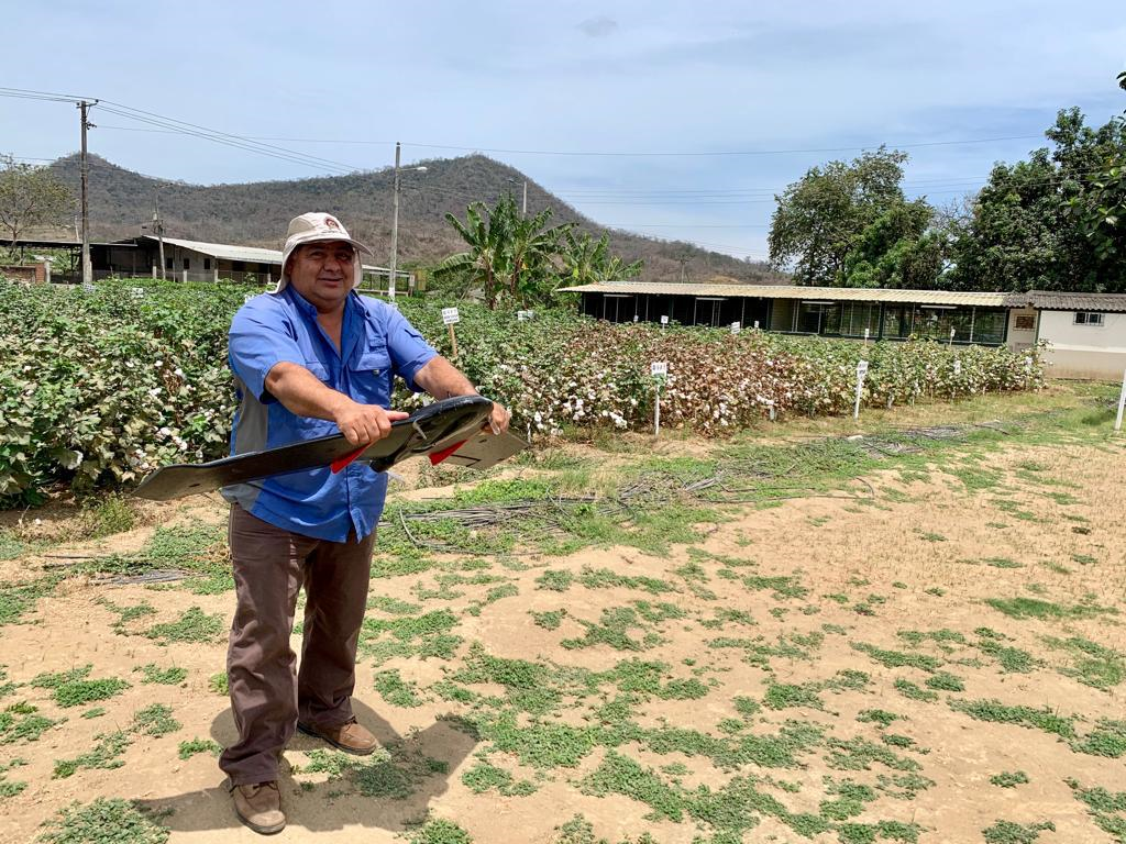
With the objective of applying remote sensing techniques for crop coefficient estimation and detection of changes in forest cover, in order to generate information that contributes to the sustainable management of agricultural and forestry resources, a study was conducted based on the theoretical foundations of agriculture 4.0, through the implementation of advanced technologies and intelligent data integration to optimize the entire agricultural production cycle. The methodology adopted includes the capture and processing of multispectral images from satellite platforms and unmanned aerial vehicles (UAVs), in order to obtain geometric and spectral information on various crops. Calculations of spectral indices (NDVI, NDMI, NDWI, Kc) and analysis of forest stand losses were performed using advanced software tools in GIS environment and the Google Earth Engine platform. The drone images made it possible to calculate the NDWI to classify soil moisture in high, moderate and low levels. Satellite images facilitated the identification of relationships between crop evaporation coefficient (Kc) and climatic parameters, as well as the detection of areas with forest losses in the Carrizal river basin. The results suggest strategies for the development of precision agriculture activities, promoting the substitution of conventional practices for sustainable development mechanisms based on geospatial technologies. This study contributes to the literature by demonstrating the application of advanced geospatial technologies to optimize agricultural production and sustainability.
Downloads
References
Basharat, U., Tariq, S., Chaudhry, M. N., Khan, M., Agyekum, E. B., Mbasso, W. F., & Kamel, S. (2023). Seasonal correlation of aerosols with soil moisture, evapotranspiration, and vegetation over Pakistan using remote sensing. Heliyon, 9(10). https://doi.org/10.1016/j.heliyon.2023.e12521
Chandramohan, K., Elayapillai, P., Vijayalakshmi, G., & Kaliraj, S. (2024). Evaluating the relation of NDVI, NDWI, SMI, and LAI to land and soil degradation processes—a case study of Virudhunagar district, Tamil Nadu, India. In Remote Sensing of Soils (pp. 689-697). Elsevier. https://doi.org/10.1016/B978-0-12-821598-5.00043-7
Chen, J. M., & Liu, J. (2020). Evolution of evapotranspiration models using thermal and shortwave remote sensing data. Remote Sensing of Environment, 237, 111594. https://doi.org/10.1016/j.rse.2019.111594
Das, S., Sharma, N., Sharma, P., & Kushwaha, N. L. (2023). Assessment of rainfall (R), evapotranspiration (ET), and crop coefficient (Kc) using satellite data. In Surface and Groundwater Resources Development and Management in Semi-arid Region: Strategies and Solutions for Sustainable Water Management (pp. 365-380). Springer International Publishing. https://doi.org/10.1007/978-3-030-51754-8_20
Datta, P., & Faroughi, S. A. (2023). A multihead LSTM technique for prognostic prediction of soil moisture. Geoderma, 433, 116452. https://doi.org/10.1016/j.geoderma.2022.116452
De La Guardia, L., de Miranda, J. H., & dos Santos Luciano, A. (2024). Assessment of irrigation water use for dry beans in center pivots using Era5 land climate variables and Sentinel-2 NDVI time series in the Brazilian Cerrado. SSRN. https://doi.org/10.2139/ssrn.4917244
Del Valle, T. M., & Jiang, P. (2022). Comparison of common classification strategies for large-scale vegetation mapping over the Google Earth Engine platform. International Journal of Applied Earth Observation and Geoinformation, 115, 103092. https://doi.org/10.1016/j.jag.2022.103092
Eliades, M., Bruggeman, A., Djuma, H., Christofi, C., & Kuells, C. (2022). Quantifying evapotranspiration and drainage losses in a semi-arid nectarine (Prunus persica var. nucipersica) field with a dynamic crop coefficient (Kc) derived from leaf area index measurements. Water, 14(5), 734. https://doi.org/10.3390/w14050734
Elogne, A. G., Piponiot, C., Zo-Bi, I. C., Amani, B. H., Van der Meersch, V., & Hérault, B. (2023). Life after fire—Long-term responses of 20 timber species in semi-deciduous forests of West Africa. Forest Ecology and Management, 538, 120977. https://doi.org/10.1016/j.foreco.2023.120977
Fuentes-Peñailillo, F., Gutter, K., Vega, R., & Silva, G. C. (2024). Transformative technologies in digital agriculture: Leveraging Internet of Things, remote sensing, and artificial intelligence for smart crop management. Journal of Sensor and Actuator Networks, 13(4), 39. https://doi.org/10.3390/jsan13040039
Ge, X., Ding, J., Jin, X., Wang, J., Chen, X., Li, X., & Xie, B. (2021). Estimating agricultural soil moisture content through UAV-based hyperspectral images in the arid region. Remote Sensing, 13(8), 1562. https://doi.org/10.3390/rs13081562
Judge, J., Liu, P. W., Monsiváis-Huertero, A., Bongiovanni, T., Chakrabarti, S., Steele-Dunne, S. C., & Cosh, M. (2021). Impact of vegetation water content information on soil moisture retrievals in agricultural regions: An analysis based on the SMAPVEX16-MicroWEX dataset. Remote Sensing of Environment, 265, 112623. https://doi.org/10.1016/j.rse.2021.112623
Ippolito, M., De Caro, D., Ciraolo, G., Minacapilli, M., & Provenzano, G. (2023). Estimating crop coefficients and actual evapotranspiration in citrus orchards with sporadic cover weeds based on ground and remote sensing data. Irrigation Science, 41(1), 5-22. https://doi.org/10.1007/s00271-022-00829-4
Karunathilake, E. M. B. M., Le, A. T., Heo, S., Chung, Y. S., & Mansoor, S. (2023). The path to smart farming: Innovations and opportunities in precision agriculture. Agriculture, 13(8), 1593. https://doi.org/10.3390/agriculture13081593
Kganyago, M., Adjorlolo, C., Mhangara, P., & Tsoeleng, L. (2024). Optical remote sensing of crop biophysical and biochemical parameters: An overview of advances in sensor technologies and machine learning algorithms for precision agriculture. Computers and Electronics in Agriculture, 218, 108730. https://doi.org/10.1016/j.compag.2024.108730
Khose, S. B., & Mailapalli, D. R. (2024). Spatial mapping of soil moisture content using very-high resolution UAV-based multispectral image analytics. Smart Agricultural Technology, 8, 100467. https://doi.org/10.1016/j.sat.2024.100467
Kumari, A., Singh, J., & Gupta, H. (2024). Multi-temporal analysis of vegetation extent using Google Earth Engine. In Natural Resource Monitoring, Planning and Management Based on Advanced Programming (pp. 29-45). Springer Nature Singapore. https://doi.org/10.1007/978-981-99-0643-5_2
Lemesios, I., & Petropoulos, G. P. (2024). Vegetation regeneration dynamics of a natural Mediterranean ecosystem following a wildfire exploiting the LANDSAT archive, Google Earth Engine, and geospatial analysis techniques. Remote Sensing Applications: Society and Environment, 34, 101153. https://doi.org/10.1016/j.rsase.2024.101153
Lobos, G., Veas, A., Balbontín, C., Muñoz, V., Franck, N., & Portilla, Á. (2017). Manejo hídrico en frutales bajo condiciones edafoclimáticas de Limarí y Choapa. Boletin INIA N° 355. Instituto de Investigaciones Agropecuarias de Chile. https://hdl.handle.net/20.500.14001/6619
Mc Feeters, S. K. (1996). The use of the Normalized Difference Water Index (NDWI) in the delineation of open water features. International Journal of Remote Sensing, 17 (7): 1425-1432. https://doi.org/10.1080/01431169608948714
Manfreda, S., & Dor, E. B. (2023). Remote sensing of the environment using unmanned aerial systems. In Unmanned Aerial Systems for Monitoring Soil, Vegetation, and Riverine Environments (pp. 3-36). https://doi.org/10.1201/9780367334232-1
Masi, M., Di Pasquale, J., Vecchio, Y., & Capitanio, F. (2023). Precision farming: Barriers of variable rate technology adoption in Italy. Land, 12(5), 1084. https://doi.org/10.3390/land12051084
Mehedi, I. M., Hanif, M. S., Bilal, M., Vellingiri, M. T., & Palaniswamy, T. (2024). Remote sensing and decision support system applications in precision agriculture: Challenges and possibilities. IEEE Access. https://doi.org/10.1109/ACCESS.2024.1234567
Munaganuri, R. K., & Yamarthi, N. R. (2024). PAMICRM: Improving precision agriculture through multimodal image analysis for crop water requirement estimation using multidomain remote sensing data samples. IEEE Access. https://doi.org/10.1109/ACCESS.2024.1234568
Pedroza-Parga, E., Velásquez-Valle, M. A., Pedroza-Sandoval, A., Sánchez-Cohen, I., & Yáñez-Chávez, L. G. (2022). The impact of vegetation cover on soil erosion and soil deposition due to runoff. Ingeniería agrícola y biosistemas, 14(1), 17-31. https://doi.org/10.5154/r.inagbi.2021.12.135
Terink, W., Lutz, A. F., Simons, G. W. H., Immerzeel, W. W., & Droogers, P. (2015). SPHY v2. 0: Spatial processes in hydrology. Geoscientific Model Development, 8(7), 2009-2034. https://doi.org/10.5194/gmd-8-2009-2015
Toosi, A., Javan, F. D., Samadzadegan, F., Mehravar, S., Kurban, A., & Azadi, H. (2022). Citrus orchard mapping in Juybar, Iran: Analysis of NDVI time series and feature fusion of multi-source satellite imageries. Ecological Informatics, 70, 101733. https://doi.org/10.1016/j.ecoinf.2022.101733
Sabie, R., Bawazir, A. S., Buenemann, M., Steele, C., & Fernald, A. (2024). Calculating Vegetation Index-Based Crop Coefficients for Alfalfa in the Mesilla Valley, New Mexico Using Harmonized Landsat Sentinel-2 (HLS) Data and Eddy Covariance Flux Tower Data. Remote Sensing, 16(16), 2876. https://doi.org/10.3390/rs16162876
Yi, W., Wang, N., Yu, H., Jiang, Y., Zhang, D., Li, X., & Xie, Z. (2024). An enhanced monitoring method for spatio-temporal dynamics of salt marsh vegetation using google earth engine. Estuarine, Coastal and Shelf Science, 298, 108658. https://doi.org/10.1016/j.ecss.2024.108658
Wu, Z., Cui, N., Zhang, W., Yang, Y., Gong, D., Liu, Q., & Zhu, B. (2024). Estimation of soil moisture in drip-irrigated citrus orchards using multi-modal UAV remote sensing. Agricultural Water Management, 302, 108972. https://doi.org/10.1016/j.agwat.2024.108972
Copyright (c) 2025 Henry Antonio Pacheco Gil, Cristhian Martin Delgado Marcillo, Roger Adrián Delgado Alcívar, Luis Fernando Fernández Zambrano, Néstor Erick Caal Suc, Emilio José Jarre Castro

This work is licensed under a Creative Commons Attribution-NonCommercial-ShareAlike 4.0 International License.